California's Emergency Policy, Planning, and Management for People with DisabilitiesMay 2023
Analyzing California's emergency management legislation, 2019 Assembly Bill 477 and Senate Bill 99, and evaluating its effectiveness in safeguarding individuals with disabilities. |
|
Taylor Yard G2 Parcel: Environmental Analysis & Design ProposalMarch 2023
Master capstone report for the University of Southern California Urban Planning program. The report evaluates the Taylor Yard G2 parcel, Los Angeles' former railyard site. I offer site plan recommendations for environmental remediation and community activation. |
|
Geospatial Package: Community Forest Grant ProgramDecember 2022
Finding low-income communities with low tree canopy in the city of Los Angeles who could benefit from the CAL FIRE’s Urban and Community Forestry Grant Program. The Tool specifically looks to identify vacant lots in these communities where applicants can purchase to covert to green space using grant funding. |
|
The Harper Project Draft Environmental Impact ReportDecember 2022
The Harper Project is a proposed mix-use development in the Los Angeles West Hollywood neighborhood. This report examines the degree to which the proposed project's short-term construction and ongoing operations may result in significant environmental impacts regarding air quality, noise, and transportation. |
|
Mountains to Sound Greenway National Heritage Area Management PlanJune 2022
This National Heritage Area (NHA) Management Plan outlines the narratives and stories that define the Mountains to Sound Greenway NHA and lays out a plan for the interpretation and preservation of its resources. |
|
The Small Business Transit SubsidyJune 2019
A Puget Sound regional program that offered 50% rebate on the cost of ORCA (transit pass) subsidies for smaller employers that had never before offered transit subsidies to their employees. |
|
Climate Mitigation, Adaptation, and Resilience in Boston and AmsterdamMay 2022
We drew a comparison between Boston, Massachusetts and the Netherlands’ capital city of Amsterdam climate mitigation and adaptation plans. The two cities exhibit unique points of overlap with zero-carbon mobility, renewable energy, disaster preparedness, and waterfront/public realm infrastructure. |
|
Segregation by Design MemorandumMarch 2022
The disparate impact and segregation resulting from past planning decisions |
|
Caste: The Origins of Our Discontents
February 2022
Reflection of Isabel Wilkerson’s book Caste and response to the role and responsibilities of city planners |
|
Public health disparities in Wilmington in connection to air qualityDecember 2021
The community of Wilmington, California is classified as the diesel death zone as a result of heavy toxic exposure from major ports, refineries, oil fields, industrial facilities, and highly trafficked transportation corridors. |
|
Seattle Waterfront: Opportunities for Social Service EnrichmentDecember 2015
Worked with the Friends of the Waterfront to create a more inclusive space with this community while also helping improve circumstances. Report was later requested by the Seattle office of the American Institute of Architects to further investigate this space and community. |
|
Whatcom County, Washington: Hazard Mitigation Scenario PlanningAugust 2016
|
Capabilities include approaches and tools. Approaches provide the method used to achieve an objective, which in this case is to reduce risk to an asset. Approaches can be classified as accommodation, protection, or retreat. Tools implement an approach and are methods for creating change. Tools can include revenue, grants, regulation, and warning. Some of the capabilities explored in this report apply to only one case study, and some apply to multiple case studies. Approaches Accommodate Accommodation strategies support activities that enable human well-being to take place within a hazard area. This involves configuring an asset (like a house) to minimize adverse impacts from a hazard. An approach for accommodation is regulating development in hazardous areas. Tools for regulation include strengthening critical area ordinances, giving developers expanded development rights in exchange for mitigation retrofits, restrictive covenants, and creating special assessment districts in high-risk areas to pay for hazard mitigation projects. Another approach is to limit the density of development. Tools for this approach include increasing minimum lot size for development, creating agricultural use districts, and establishing a procedure for using floating zones to reduce densities in areas damaged by a disaster. A third approach is to use land use regulations to decrease risk. Tools include bonus/incentive zoning to incentivize mitigation measures, conditional use zoning to require mitigation measures, overlay zones that require mitigation measures, and adopt a post-disaster recovery ordinance that regulates repairs. A fourth approach is hazard education. Tools include creating a multi-hazard public awareness program, creating a hazard information center, holding an annual public hazard workshop, and boosting private sector hazard awareness. Protect Protection strategies aim to keep the hazard out of an area. Retreat Retreat strategies move human activities away from hazardous areas. One retreat approach would be to prevent development in hazardous areas. There are many tools available to implement this approach, including capital improvement planning, purchasing the “right of first refusal” for parcels at risk of a hazard, purchasing at risk properties, obtaining easements to prevent development, and creating a transfer of development rights program. SCENARIO PLANNING
Read our ‘Planning Through Story Telling: a Sea Level Rise Case Study’ on the Washington Coastal Network blog. Scenario planning provides a framework for making decisions about the future. It recognizes that the future is uncertain, and alternative scenarios characterize different plausible outcomes. Scenarios that provide possible future baseline conditions can be used to evaluate alternative strategies, to determine what strategies are common to a range of scenarios and what approaches and tools can limit future flexibility and courses of action, and to create trajectories or drivers of change. The project team used trajectories identified through the Puget Sound Future Scenarios project (University of Washington Urban Ecology Research Lab 2008). 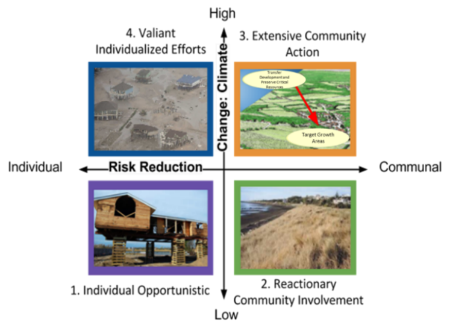
Driving forces This scenario uses two sets of drivers – the intensity of hazard impact and the City’s willingness to use City capital to reduce risks. The impact of the hazards will create either a high or low level of change. A low level of change means the buildings and infrastructure of the area experience some damage after a hazard occurs, but can be repaired and reuses. A high level of damage means the buildings and infrastructure of an area would have to be replaced. The responsibility for risk reduction could either fall to the property owner (internalized) or the larger community (externalized). If property owners are responsible for risk they will have greater degree of choice about how to use their land and they alone will experience the benefit or loss that results from their decisions. In this case the government would not subsidize shore protection or coastal development. If the community is responsible for risk property owners will be accept more regulations in exchange for government support addressing climate change impacts. Sandy Point: Sea level rise
This case study focuses on mitigating the impacts of flooding in Sandy Point, a community located on Puget Sound in Whatcom County, WA. We use geospatial data to profile the hazard according to three different projections of sea level rise by the year 2100 (4 inches, 24 inches, and 5 feet), each of which poses threats to built, natural, and social capital in the community. We offer four planning scenarios integrating climate change (ranging from low to high) and culture (ranging from individualistic to community-based); for each scenario, we interpret the impacts and feasibility. In addition to providing actionable knowledge for planners in Whatcom County, this study has conceptual implications for floodplain management and climate resilience in other coastal communities of the United States. 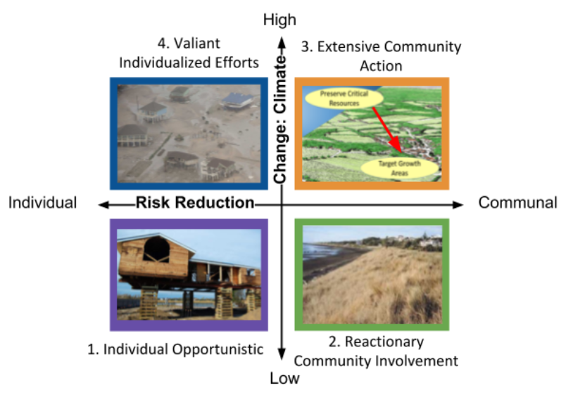
Hail Mary (high climate change and internalized risk reduction) In the face quickly rising seas and more frequent severe storms landowners take advantage of little regulatory restriction and implement individual measures to protect their property. Landowners carefully weigh the potential risks and rewards when building and redeveloping their properties, knowing the government will not subsidize any shoreline protection or rebuilding in the case of damage. Some properties remain undeveloped or unimproved because the property owners do not think the properties will be useable long enough to justify the investment. Other property owners look at the risk and decide the decades of use of the property before the sea level rises makes investment worth the risk. These property owners implement strategies like elevation and shoreline armoring. These projects are either privately financed or paid for with NFIP funds. Hard armoring prevents the inland migration of wetlands, interferes with public beach access, and causes neighboring properties to erode at a faster pace. Eventually properties are abandoned because of the high costs of protecting against climate change impacts. Homeowners are not required to remove structures and housing parts litter the beach. Whole Nine Yards (high climate change and externalized risk reduction) Property owners accept more regulation in exchange for support from the government. Early on the government offers programs that subsidize home elevation and soft armoring to reduce the chance of damage from storms. Rolling easements prevent hard armoring and allow the shoreline, beach, and wetlands to naturally move inland. Property owners that would have implemented shoreline protections may not be able to use their properties for as long, but overall the land and beach will erode at a slower pace because of this restriction. When the land is no longer useable structures are removed and the wetlands are restored. Car Wash (low climate change and externalized risk reduction) Because there is little sea level rise and a smaller increase in severe storms, a only a few interventions are required to keep the area habitable. The government helps property owners with home elevation, soft armoring and nearshore biological enhancements. In exchange for government help homeowners are prevented from hard armoring their individual properties. Property owners can continue to use their land and the local government can continue to collect property taxes in the area. Scavenger Hunt (low climate change and internalized risk reduction) Homeowners have the responsibility for choosing and paying for strategies that protect their homes from the small increase in sea level rise and severe storms. These strategies include home elevation, soft armoring, and hard armoring. The hard armoring of some properties leads to loss of beach and increased erosion on neighboring properties. Homeowners that do not have financial resources to elevate or armor their property either sell their early homes or use them until a storm causes substantial damage. Strategy Discussion: The two strategies that all scenarios have in common are home elevation and soft armoring. These two options will be sufficient for a small amount of sea level, and depending on the rate of sea level rise and property values would likely be cost effective. Ferndale: Multiple hazard around the Nooksack River
Hazard Profile The City of Ferndale is at risk of earthquakes, flooding, geologic hazards, severe storms, volcano, and wildland fire. However, this case study focuses only on the area Ferndale adjacent to the Nooksack River, which is at risk for flooding, liquefaction during and earthquake, and volcanic debris. The area around the Nooksack River at risk of multiple hazards is home to a number of land uses. These uses include commercial, multi-family residential, single family residential, and industrial. A good deal of land in this multi-hazard area is currently undeveloped. 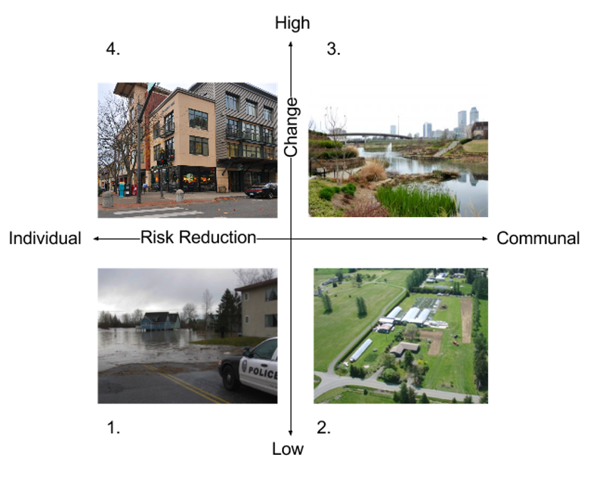
Four Stories 1. Low Change & Individual Over the years flooding occurs more frequently and the floods impact a wider area than in the past. What was once the 100-year floodplain turns into a 60-year floodplain. Some homeowners are able to take advantage of NFIP programs to elevate their homes. Some businesses in the area wet-proof their buildings to reduce damage from floods. During large storms roads are flooded, preventing homeowners from either accessing or leaving their homes. The local government offers bonus & incentive zoning to property owners in exchange for extra hazard mitigation measures. The multiple hazard area also becomes a special assessment district to fund more mitigation measures. These strategies increase the density in the area and cause more parcels to be developed, but the new development is better equipped to withstand hazards. More people are inconvenienced when an earthquake occurs, but the added mitigation measures lessen the damage. 2. Low Change & Communal As years pass flood events become more intense and happen more frequently. In response the local government limits development in multi-hazard areas with strategies like increasing minimum lot size, creating agricultural use districts, purchasing easements, and capital improvement planning. There is little development in the area, but also few funds for hazard mitigation projects. A few people and structures are impacted by flooding and liquefaction, but the overall cost of repair is low. 3. High Change & Communal Climate change is having quick and severe impacts in Washington State. Flooding events are happening more frequently and with more intensity then before. What was once a 100-year floodplain turns into a 20-year floodplain. Recognizing this change in conditions and the risk earthquakes and lahars pose to the area, the City of Ferndale puts programs in place to discourage development in hazardous areas. Instead of spending money to build more levees and continually repair existing ones, the City buys land closest to the River to create open space. It also down zones the hazardous areas to prevent extensive investment that would be greatly at risk. Development is redirected to safer areas through a transfer of development rights program and capital improvement planning. Because there is little to no development in the area, when a large hazardous event occurs there is little damage. 4. High Change & independent Hazard events are frequent and funds for hazard mitigation primary come from the multiple hazard area property owners. The local government uses bonus/incentive zoning and a special district assessment to achieve added mitigation. Development in the area grows, and the added mitigation measures make it possible to withstand the flooding hazard most years with little damage. But these mitigation measures only go so far, and when a large earthquake or flood effects the area a large number of people experience a substantial amount of damage.
What is a coastal bluff?
Coastal bluffs are steep faces of sediment or soil. This type of surface is subject to erosion from waves. Coastal bluffs supply large amounts of sand to perched dunes and other dune formations through erosion and subsequent natural movement of sand along the shoreline. They can be composed of sand, gravel, or clay. What are the risks? Washington is one of seven states listed by FEMA as being especially vulnerable to severe land stability problems. In some areas where the shoreline is a bluff, coastal erosion and/or improper drainage can threaten the structural integrity of residential structures and the stability of the bluff itself. Residential areas are at an increased risk of bluff collapse and landslides due to
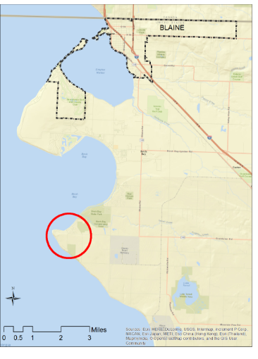
Hazard ProfileBluff erosion and landslides have several contributing factors. Wave action erodes the toe of bluffs and causes instability. When bluffs lose this lateral support, it is more likely large pieces of the bluff will fail. Heavy rain and drainage failures can lead to small landslides and elevated groundwater levels or seismic activity can trigger large landslides. In the future climate change will cause sea level rise and more frequent storm events. The combination of more storms with large waves and high tides/elevated sea levels will likely contribute to an increase in bluff erosion (Climate Impacts Group 2009). The magnitude of climate change is uncertain, and after the mid-21st century will depend greatly on future greenhouse gas emission levels (IPCC 2014). Sea level is projected to increase by 24 inches by 2100, but could range from also low as 4 inches to 56 inches (National Academy of Sciences 2012). The Birch Bay area has historically been developed with seasonal homes, resort/recreation uses and business. This area has grown quickly in the last 20 years and now has more full time residents. Today land uses in Birch Bay include year round homes, vacation rentals, RV parks, mobile home parks, condominiums, restaurants, shops, and a state park (Whatcom County 2015). CapabilitiesThe Washington State Department of Ecology has created an outline of recommendations to help prepare the public on current and potential new development within the bluff areas. This outline recommends individuals who are interested in investing in coastal property to do research on the history of the property, get advice from licensed geologist before purchasing potentially unstable property, leave a safe setback from the slope, maintain existing vegetation on and below the bluff to help prevent erosion and absorb excess water, and finally maintain drainage system to help convey water away from the slope. These recommendations can be found in the updated 2015 Whatcom Hazard Mitigation Plan. The primary recommendation provided in the Whatcom HMP is to limit or eliminate development employing buyouts of especially high risk areas on reoccurring landslides should be considered. We are looking to further develop this outline of recommendations as well as find additional capabilities for both residents to act on independently and for Blaine government to act on collectively. Ideally, we want to protect current residents from bluff collapse while maintaining the sense of shoreline aesthetics. Scenario Focal Issues: This assessment explores the different strategies Whatcom County could pursue to foster sustainable and safe development in and around the Point Whitehorn coastal bluff. 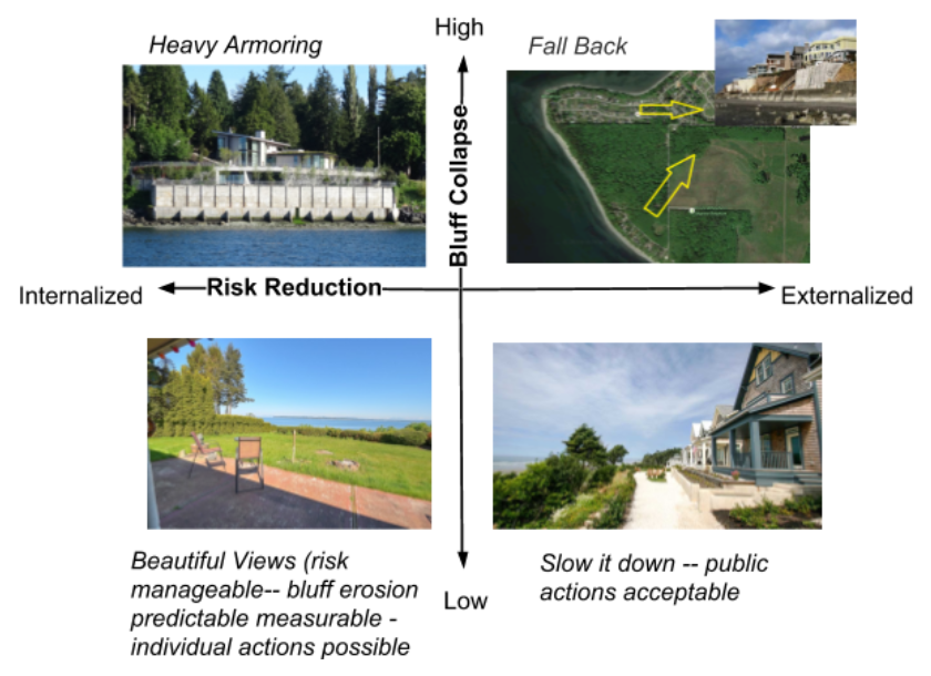
Heavy Armoring (Internalized Risk and High Bluff Collapse)
Fall Back (Externalized Risk and High Bluff Collapse)
Slow it Down (Externalized Risk and Low Bluff Collapse)
Beautiful Views
|
GIS Analysis: BellinghamJune 2016
Mitigating hazards by applying regulations on undeveloped property |
|
